Geospatial Analysis and Mapping
Overview of Floyd|Snider Contributions
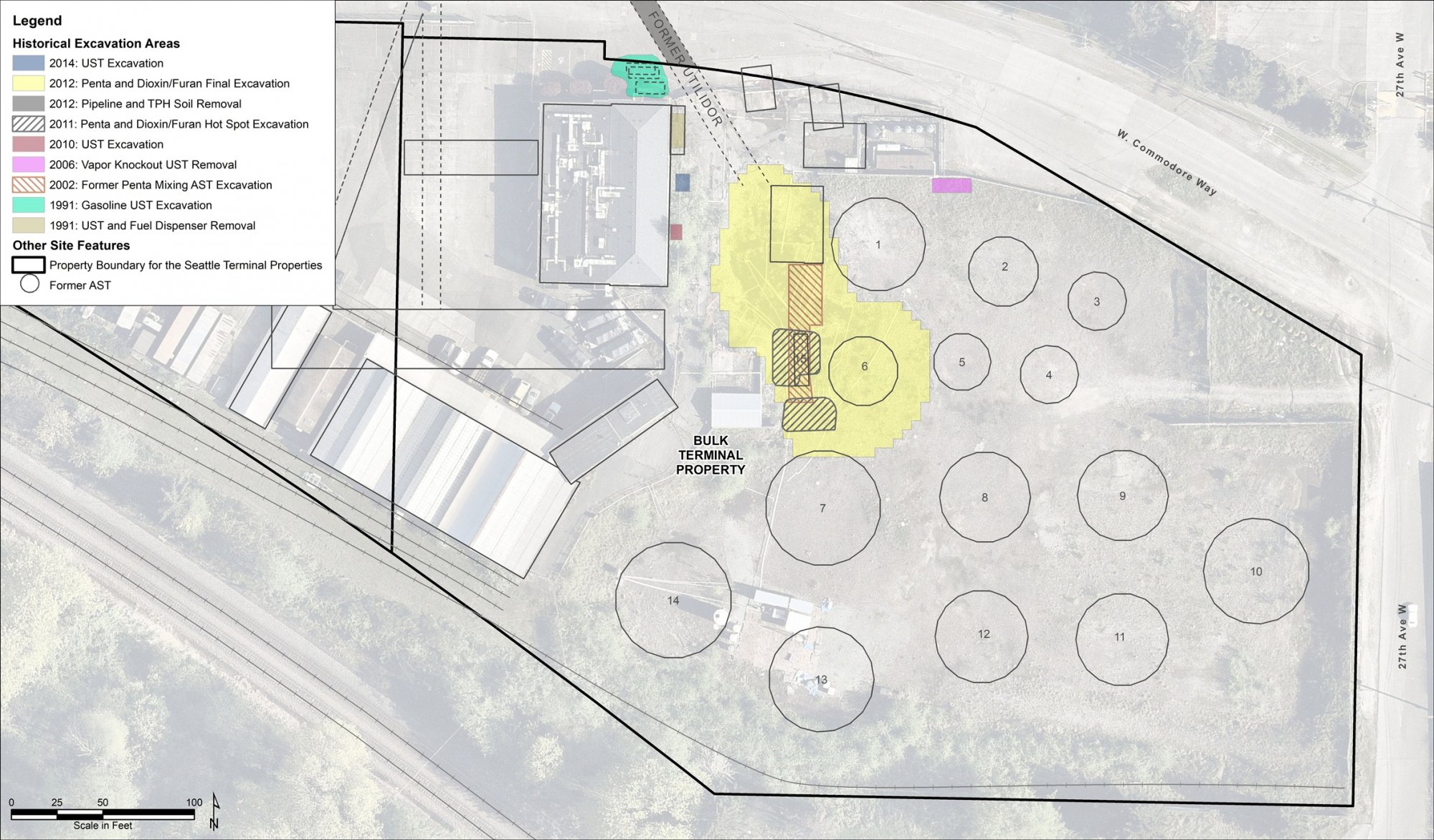
Time Oil Seattle Terminal PPA Historical Soil Excavation Areas – Bulk Terminal Property. Floyd|Snider evaluated four parcels in a Remedial Investigation/Feasibility Study as part of a due diligence process before Cantera Development Group, LLC purchased the properties. This figure shows the historical excavation areas from numerous interim cleanup actions.

River Mile 3.5 East Remedial Design Depth of Contamination. The Floyd|Snider team supports Radius Recycling in remediation of the River Mile 3.5 East Project Area within the Portland Harbor Superfund Site. The depth of contamination interpolates data for contaminants of concern to inform the basis of design.
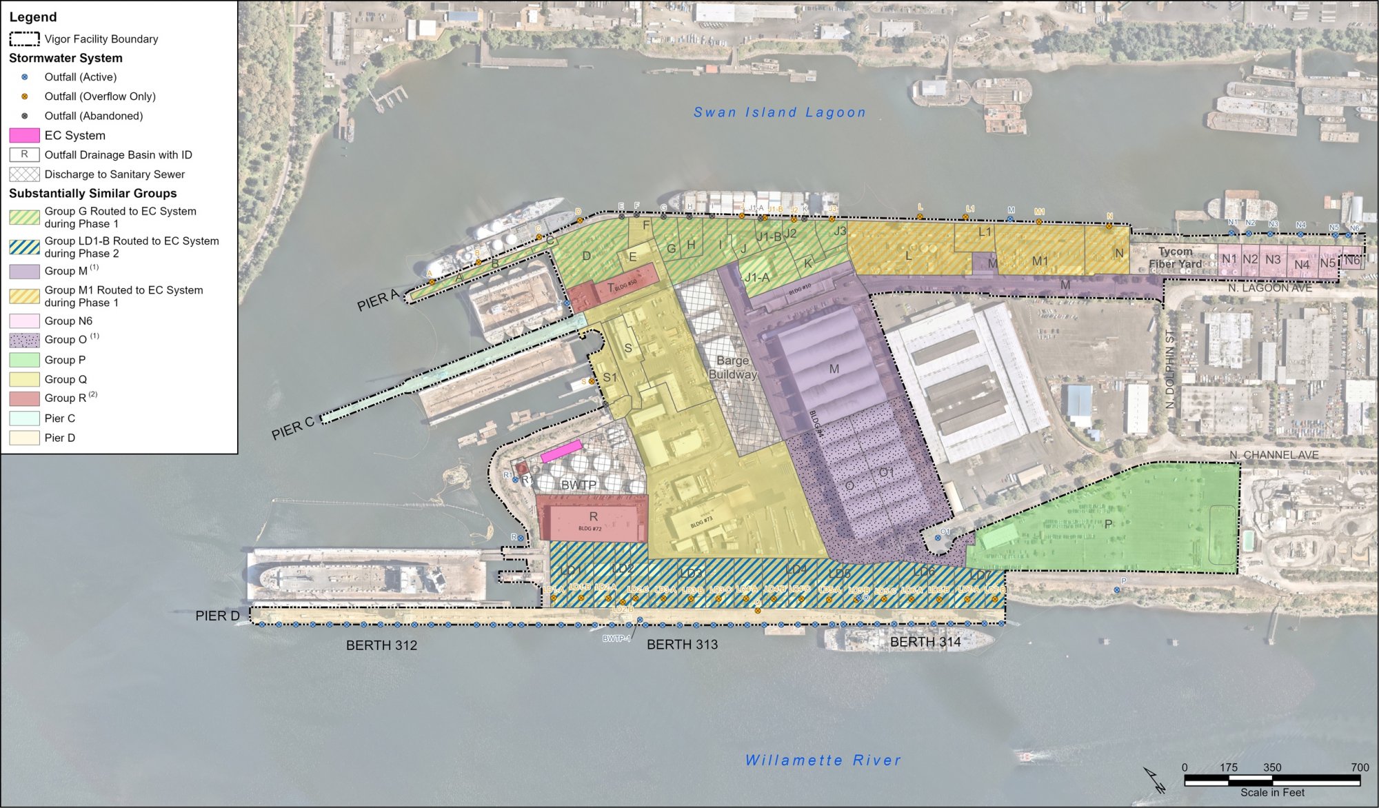
Vigor-Portland Substantially Similar Basin Groups. Floyd|Snider performs stormwater compliance and source control work for Vigor Industrial in accordance with an Order of Consent issued by the Oregon Department of Environmental Quality. The figure shows how substantially similar basins were grouped to reduce the number of monitoring locations. Learn more about the project.
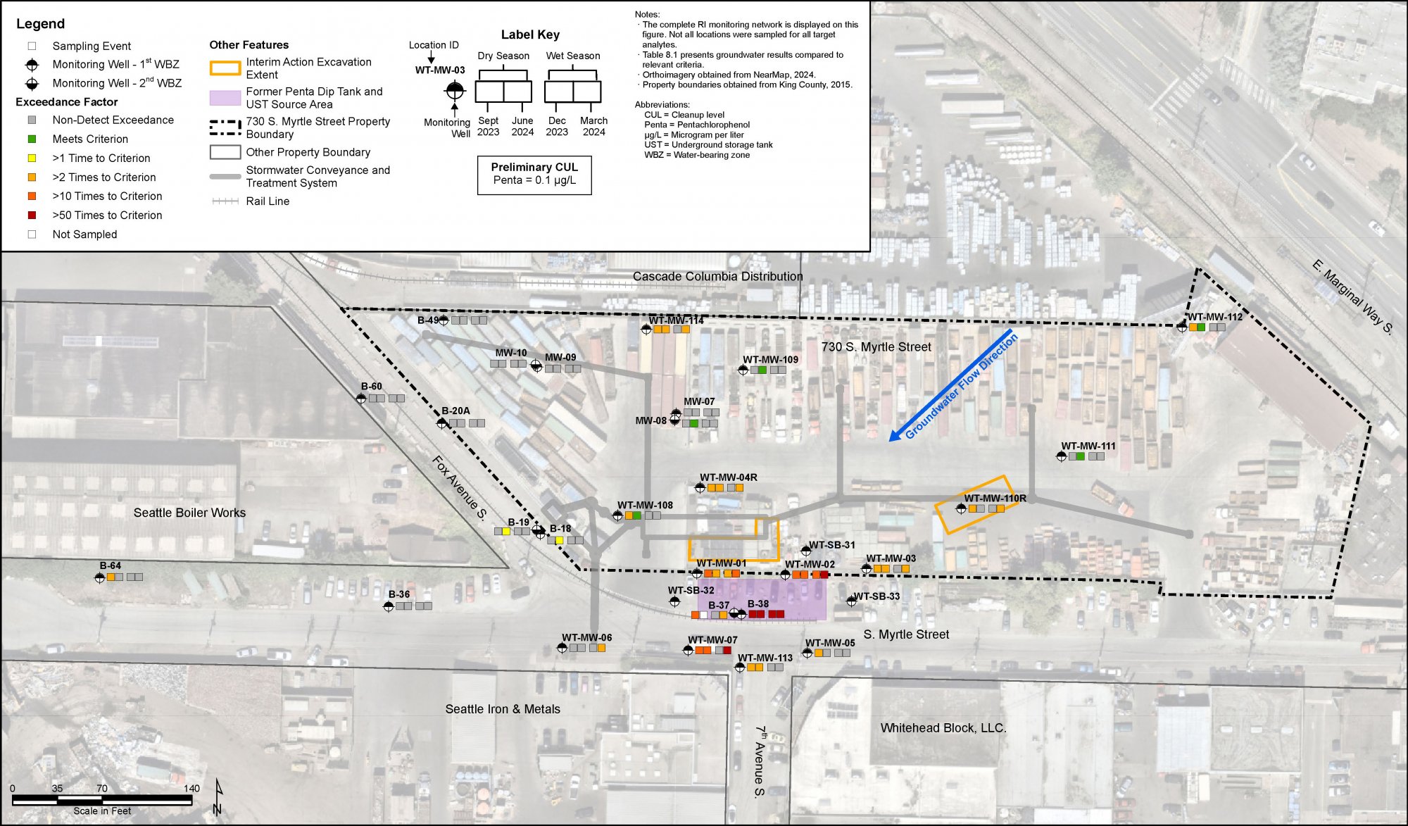
Whitehead Tyee Site Pentachlorophenol Distribution in Groundwater. Floyd|Snider is working with 730 Myrtle LLC and Seattle Iron & Metals Corp to prepare a Remedial Investigation/Feasibility Study for the Whitehead Tyee Site. This figure shows the nature and extent of contamination in groundwater for one of the Site’s primary chemicals of concern.
Quick Mart, Eisen Chevron-Colony October 2023 Groundwater Contours. Floyd|Snider prepared a Focused Feasibility Study and Cleanup Action Plan for Quick Mart/Eisen Chevron—Colony under Washington State’s Pollution Liability Insurance Agency’s Petroleum Technical Assistance Program. Floyd|Snider collected groundwater samples to evaluate Site conditions.
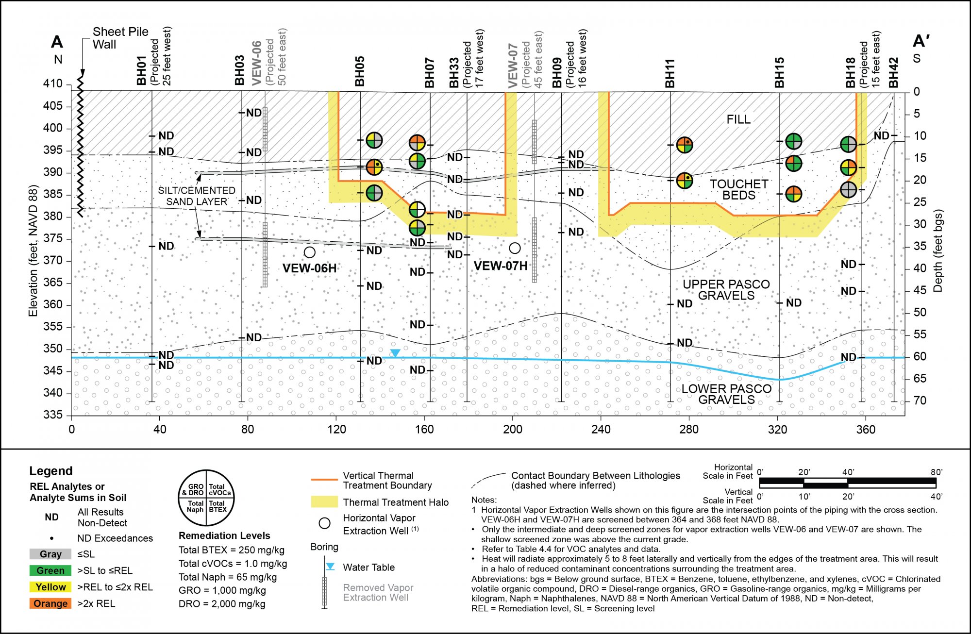
IWAG-Pasco Cross Section A-A’ Extent of Remediation Level Exceedance. Floyd|Snider is working with Industrial Waste Area Generators Group III to address the Pasco Sanitary Landfill National Priorities List site, including preparing an Engineering Design Report. This cross section shows the extent of contamination that requires active remediation. Learn more about the project.
Our Approach
Our team of GIS analysts leverages a variety of geo-analytical tools to perform complex analysis to support our ability to meet client goals. The conclusions derived from these analyses can then be used to create site maps that are both rich in data and visually appealing. These visualizations offer a clear way to understand site dynamics and support informed decision-making at all stages of the project.
Our Approach
Geospatial analysis is an integral part of nearly every project at Floyd|Snider. Our team of GIS analysts leverages a variety of geo-analytical tools to perform complex analysis to support our ability to meet client goals. The conclusions derived from these analyses can then be used to create site maps that are both rich in data and visually appealing. These visualizations offer a clear way to understand site dynamics and support informed decision-making at all stages of the project.
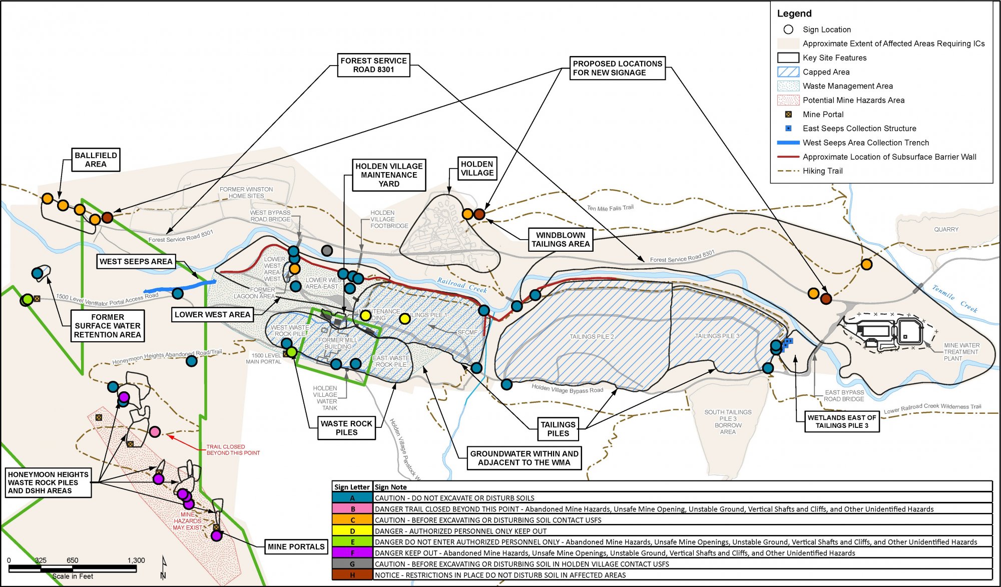
Holden Mine Site Existing and Proposed Signage Locations. This figure represents locations of hazard signs for the Holden Mine Site that were installed as part of the Institutional Control Implementation and Assurance Plan. Learn more about how the Floyd|Snider team’s approach to data collection and evaluation supports remediation of the Holden Mine Site.
Tools & Software
ArcGIS Pro and ArcGIS Online
Google Earth and Nearmap
Python
Arcade
Adobe Creative Suite